Take action to protect yourself and others – extreme heat can affect everyone’s health. Determine if you or others around you are at greater risk of heat illness. Check on older adults, those living alone and other at-risk people in-person or on the phone multiple times a day.

Watch for the early signs of heat exhaustion in yourself and others. Signs may include headache, nausea, dizziness, thirst, dark urine and intense fatigue. Stop your activity and drink water.

Heat stroke is a medical emergency! Call 9-1-1 or your emergency health provider if you, or someone around you, is showing signs of heat stroke which can include red and hot skin, dizziness, nausea, confusion and change in consciousness. While you wait for medical attention, try to cool the person by moving them to a cool place, removing extra clothing, applying cold water or ice packs around the body.

Drink water often and before you feel thirsty to replace fluids.

Close blinds, or shades and open windows if outside is cooler than inside.

Turn on air conditioning, use a fan, or move to a cooler area of your living space. If your living space is hot, move to a cool public space such as a cooling centre, community centre, library or shaded park.

Follow the advice of your region’s public health authority.

Plan and schedule outdoor activities during the coolest parts of the day.

Limit direct exposure to the sun and heat. Wear lightweight, light-coloured, loose-fitting clothing and a wide-brimmed hat.

Never leave people, especially children, or pets inside a parked vehicle. Check the vehicle before locking to make sure no one is left behind.

A prolonged period of near heat warning levels begins today.

What:
Daytime highs of 29 to 32 degrees Celsius and a humidex of 35 to 40.
Overnight lows of 19 to 23 degrees Celsius, providing little relief from the heat.

When:
Today, possibly to Thursday.

Additional information:
This week southern Ontario will experience hot and humid conditions. The temperatures and humidex will meet or be extremely close to heat warning criteria, with the hottest day being Saturday. A shift in the weather pattern on Thursday will likely end this multi-day period of heat and humidity.

###

For more information: https://www.canada.ca/en/health-canada/services/climate-change-health/extreme-heat/how-protect-yourself.html https://www.canada.ca/en/health-canada/services/climate-change-health/extreme-heat/who-is-at-risk.html

Please continue to monitor alerts and forecasts issued by Environment Canada. To report severe weather, send an email to ONstorm@ec.gc.ca or post reports on X using #ONStorm.
The water is a good spot to be, as a heat wave hits parts of Ontario this week.
As predicted by weather watchers, temperatures are warming up across the province.
But the experts have erred on the side of caution, with Environment and Climate Change Canada sharing for many parts of the province, starting today, Friday, July 11.
“A prolonged period of near heat warning levels begins today,” the weather agency said in its news release, adding daytime highs of 29-32 C, plus a humidex of 35 to 40, are anticipated.
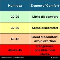
Humidex levels are measured in Celsius so people know what to expect, and are graded by how much discomfort you can feel.
Environment Canada graphic
ARTICLE CONTINUES BELOW
Areas impacted include the Niagara area, Halton Region, Peel Region, Durham Region, York Region, Windsor, Kawartha Lakes, Peterborough and öĎÓăĘÓƵapp.
Places further north like Simcoe County, Muskoka, and Parry Sound have not been included in the heat alert thus far.
ARTICLE CONTINUES BELOW
In the impacted areas, it’s not going to cool down much at nighttime either, with overnight lows between 19 C and 23 C, providing little relief from the heat.
ARTICLE CONTINUES BELOW
And the hot streak is expected to last until at least next Thursday.
“This week, southern Ontario will experience hot and humid conditions,” Environment Canada said. “The temperatures and humidex will meet or be extremely close to heat warning criteria, with the hottest day being Saturday.”
Environment Canada issues a heat warning when the daytime temperature is at least 31 C for two days, with overnight lows that stay 20 C or above.
Warning preparedness meteorologist Steven Flisfeder said temperatures are right on the cusp of those requirements, and although they may fluctuate day-to-day, an alert was issued.
“Our mandate as meteorologists is to keep the public safe — and with six or more days of these (high) temperatures, we decided to issue a warning,” he said.
Showers expected
ARTICLE CONTINUES BELOW
While some rainfall is expected, it likely won’t cool anything down.
Parts of southwestern Ontario may see some showers first thing Saturday morning, which may cool things off by a degree or two.
But it will still be a muggy, humid day.
“Through Saturday, there will definitely be some clouds moving in. There’s a low-pressure system right at the junction of Lake Superior at Georgian Bay,” Flisfeder said. “That’s going to bring the possibility of thunderstorms for Saturday evening through overnight, across southern Ontario.”
Areas in cottage country and extreme southwestern Ontario are the most likely to experience these late-day thunderstorms, he said.
Following that, more sunshine is in the forecast, lasting until Thursday.
A shift in the weather pattern on Thursday will likely end this multiday period of heat and humidity, Environment Canada said.
ARTICLE CONTINUES BELOW
“Thursday looks like another system coming in, right now it looks like it’s more on the precipitation side,” Flisfeder said. “It could provide much-needed rain for many areas, because it’s been very dry for a few weeks.”
Watch for heat illness
Until things cool off, weather experts advise people stay safe.
Extreme heat can affect everyone’s health in different ways — some may feel it more extreme than others.
“Determine if you or others around you are at greater risk of heat illness. Check on older adults, those living alone and other at-risk people in-person or on the phone multiple times a day.”
Watch for the early signs of heat exhaustion in yourself and others.
Signs may include headache, nausea, dizziness, thirst, dark urine and intense fatigue. Stop your activity and drink water.
ARTICLE CONTINUES BELOW
Heat stroke is considered a medical emergency. Call 911 or your emergency health provider if you, or someone around you, is showing signs of heat stroke which can include red and hot skin, dizziness, nausea, confusion and change in consciousness. While you wait for medical attention, try to cool the person by moving them to a cool place, removing extra clothing, applying cold water or ice packs around the body.
Here are some tips to stay cooler in the heat:
Drink water often and before you feel thirsty to replace fluids.
Close blinds, or shades and open windows if outside is cooler than inside.
Turn on air conditioning, use a fan, or move to a cooler area of your living space. If your living space is hot, move to a cool public space such as a cooling centre, community centre, library or shaded park.
Follow the advice of your region’s public health authority.
Plan and schedule outdoor activities during the coolest parts of the day.
Limit direct exposure to the sun and heat. Wear lightweight, light-coloured, loose-fitting clothing and a wide-brimmed hat.
Never leave people, especially children, or pets inside a parked vehicle. Check the vehicle before locking to make sure no one is left behind.
Today's Headlines Newsletter
Get our free morning newsletter
Error! Sorry, there was an error processing your request.
There was a problem with the recaptcha. Please try again.
You may unsubscribe at any time. By signing up, you agree to our and . This site is protected by reCAPTCHA and the Google and apply.
Today's Headlines Newsletter
You're signed up! You'll start getting Today's Headlines in your inbox soon.
Want more of the latest from us? Sign up for more at our newsletter page.
Janis Ramsay is an online editor with Metroland. Reach her at
jramsay@metroland.com.
Your gift purchase was successful!Your purchase was successful, and you are now logged in. You will also start receiving our free morning newsletter soon.


To join the conversation set a first and last name in your user profile.
Sign in or register for free to join the Conversation