Things are going to be hot, hot, hot across most of Ontario for the next week or so.
And there’s little reprieve from the sun — a forecast many have been waiting for.
According to Environment and Climate Change Canada, temperatures are going to be above-normal starting today (July 10), running through to next Thursday.
ARTICLE CONTINUES BELOW
Warm and sunny
“Generally speaking, areas with a higher population density — places like Ottawa, the GTA and Windsor, Sarnia and Niagara peninsula as well — they are looking at daytime highs of high-20s into the 30s pretty much every day,” warning preparedness meteorologist Steven Flisfeder said.
ARTICLE CONTINUES BELOW
With that, we can expect to see humidity levels into the mid-30s.
Places like Algonquin Park, around Georgian Bay and Lake Erie, won’t see temperatures quite as high, however.
ARTICLE CONTINUES BELOW
“They’ll still be fairly consistently warm through. Some of those areas can get into the high 20s, but the nearer you are to water, you’re more likely to see just the mid-20s for that same period,” said Flisfeder.
ARTICLE CONTINUES BELOW
Flisfeder said temperatures in the mid-20s is normal for the beginning of July in Ontario, so seeing spikes into the 30s is higher than normal.
“The second half of July into the first one or two weeks of August, that’s the peak, but even then, the average highs are usually 26 or 27 C.”
There’s also not a lot of incoming precipitation on the radar systems, which would potentially help cool things down a bit.
Not related to heat dome
When asked if this streak of warm weather is part of the predicted heat dome hanging over the United States and into Canada this summer, Flisfeder said this doesn’t count.
“A heat dome requires temperatures to be much hotter, (but) it’s the same kind of mechanism, where we have a high-pressure system is locking temperatures in place, keeping it on the high side,” he said. “Since they’re not extreme temperatures, into the high 30s, technically it does not qualify as a heat dome.”
But we are seeing the duration needed to meet that criteria, with the heat coming for at least seven days.
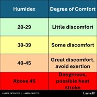
Humidity concerns
As warm as the actual temperature will be, adding to that is the humidex, or the hot-dewy air around you.
“It will be humid, but it won’t be as extreme as we saw through the last heat event in the middle of June,” Flisfeder said. “It will be uncomfortable based on your personal preference.”
The humidex could be into the mid-to-high 30s next Tuesday and Wednesday in the GTA, Ottawa, Windsor and Niagara areas — if not hotter.
For those in the Algonquin Park, Lake Simcoe, Georgian Bay and Lake Erie areas, it won’t be quite as humid, but expect 30 C plus temperatures.
ARTICLE CONTINUES BELOW
Flisfeder said there isn’t an exact unit of measurement for the humidex.
It’s quoted in degrees Celsius, so people have an idea of how warm it will be. But it’s an index or level.
Humidex levels are measured in Celsius so people know what to expect, and are graded by how much discomfort you can feel.
Environment Canada graphic
“It measures discomfort value. When we talk about discomfort levels being high, it’s due to the amount of moisture present in the atmosphere around you,” he said. “It causes discomfort because you’re sweating, but it doesn’t evaporate, so your body isn’t able to cool off as efficiently as if there was less humidity.”Â
Flisfeder said meteorologists measure the humidex using the dew point and temperatures.
“The higher the dew point, the higher the humidity.”
For those with existing health conditions, like asthma or cardiac concerns, or for children, the elderly or pregnant persons, the higher humidity may impact them sooner than others not facing any age or health-related issues.
ARTICLE CONTINUES BELOW
When asked if humid conditions are anticipated for the rest of the summer, Flisfeder said Environment Canada is unable to provide long-term forecasts for humidity.
Wildfires not adding to the heat wave
While many headlines were talking about the northern Ontario and prairie wildfires a few weeks ago, that has died down.
Currently, there are and monitoring.
“If there was a blanket of smoke over a region — which there is in far northern Ontario — it would act as a potential blanket, so limiting solar radiation and how high the temperatures could get,” he said. “Southern Ontario doesn’t have a high enough concentration of smoke making its way into the region.”
As winds and wildfire activity changes, that could impact the temperatures and humidity levels in the southern parts of the province, he added.
How to combat the heat
ARTICLE CONTINUES BELOW
Tips to stay cool include avoiding strenuous outdoor activities when the sun is at its peak, usually in the mid-afternoon.
“Even if there’s no (extreme heat) warnings in effect, you can still be affected by the heat,” Flisfeder said. “If you have strenuous activity you can’t postpone, do it during the early morning hours or late in the evening.”
Drink lots of water — even before you get thirsty. Wear cool, light clothing, seek shade when possible. Wear sunscreen, hats and sunglasses as well.
It’s likely some municipalities may choose to open cooling centres during the hot week ahead, but there’s no specific guideline that orders them to open the facilities.
Flisfeder said he doesn’t anticipate any extreme heat warnings this weekend, but one could come into play next Tuesday.
Temperatures across most of Ontario have to be 31 C for at least two days, with overnight lows in the 20s to activate an extreme heat warning.
ARTICLE CONTINUES BELOW
To stay up-to-date on the weather forecast, visit  or download the  to your smartphone.
Today's Headlines Newsletter
Get our free morning newsletter
Error! Sorry, there was an error processing your request.
There was a problem with the recaptcha. Please try again.
You may unsubscribe at any time. By signing up, you agree to our and . This site is protected by reCAPTCHA and the Google and apply.
Today's Headlines Newsletter
You're signed up! You'll start getting Today's Headlines in your inbox soon.
Want more of the latest from us? Sign up for more at our newsletter page.
🌡️The humidex shows how hot it feels with heat and humidity.
🥵When sweat can’t evaporate, we overheat faster.
âś…Stay hydrated and watch for signs of heat exhaustion or heat stroke.
is an award-winning journalist covering Simcoe County for more than 22 years. She is mom to two boys who are into sports and tech. She can be reached at JRamsay@simcoe.com. Follow Simcoe.com on X, formerly Twitter.
Your gift purchase was successful!Your purchase was successful, and you are now logged in. You will also start receiving our free morning newsletter soon.


To join the conversation set a first and last name in your user profile.
Sign in or register for free to join the Conversation